- Duration
- 3 days, ~450 km by car plus the ferry
- Who it suits
- Everyone
- Transport
- ferry, drive
- Start
- Cape Jervis ferry terminal
- Finish
- Admirals Arch
- Pace
- moderate pace
- Best time
- October–April; in summer book a car on the ferry weeks ahead
- Budget per adult
- ferry from A$49 per adult and from A$99 per car each way; Flinders Chase and Seal Bay charge entryPrices as of: October 2026
Getting there
Cape Jervis is about 1 hour 45 minutes by car from Adelaide. The SeaLink ferry to Penneshaw takes about 45 minutes and runs daily except Christmas Day. The published fare is from A$49 per adult and from A$99 for a car up to 5 m each way, but prices move with demand. Book on sealink.com.au.
Stops in order
The text version of the route: stops, time at each and the legs between them. Times are estimates, without queues, traffic or swims.
Day 1. The ferry and the east
Day in Google Maps ↗1. Cape Jervis ferry terminal~45 min at the stop
SeaLink's terminal at the tip of the Fleurieu Peninsula, where the island ferry leaves.
Tip: Honey, bee products and some other items are banned on the island; drop them in the biosecurity bins at the terminal.
Open on the map ↗↓ ferry · 45 min · 17 km
2. Penneshaw~30 min at the stop
The village by the ferry wharf, your first stop: cafe, fuel and a store.
Worth knowing: Kangaroo Island is Australia's third-largest island: 155 km long and 55 km wide.
Tip: Fill the tank here; fuel is scarce out west.
Open on the map ↗↓ drive · 50 min · 60 km
3. Kangaroo Island Spirits~1 h at the stop
A gin distillery at Cygnet River with a tasting room and botanical garden. Stay nearby in Kingscote.
Worth knowing: It opened in 2006 as Australia's first dedicated gin distillery.
Tip: Listed hours vary; check the website before you go.
Open on the map ↗
Day 2. The south coast
Day in Google Maps ↗4. Seal Bay~1 h 15 min at the stop
A colony of Australian sea lions. Since late July 2026 beach tours have been paused because of H5N1 bird flu, and in September the virus was confirmed in a sea lion at Seal Bay. Only the boardwalk tours are running.
Tip: Check before you go whether the park is open and which tours are running: the situation is changing. Usual hours are 9am–5pm, last entry 4pm.
Open on the map ↗↓ drive · 15 min · 9 km
5. Little Sahara~1 h at the stop
White dunes in the middle of the bush, made for sandboarding. Boards are hired at the entrance, about A$37 for an hour.
Tip: In summer come in the morning; by noon the sand burns.
Open on the map ↗↓ drive · 12 min · 10 km
6. Vivonne Bay~45 min at the stop
A long, empty white-sand beach with an old jetty.
Tip: Rips are strong; swimming is safer near the jetty and the river mouth.
Open on the map ↗↓ drive · 40 min · 45 km
7. Hanson Bay Wildlife Sanctuary~1 h 30 min at the stop
A sanctuary on South Coast Road with a walk among wild koalas in the gums; sunset tours too.
Worth knowing: The sanctuary is privately owned and has run since 1997 as a regenerative tourism project, with tour income going back into the land and wildlife.
Tip: Guided walks from A$35 per the state tourism listing; book sunset tours ahead.
Open on the map ↗
Day 3. Flinders Chase and back
Day in Google Maps ↗8. Remarkable Rocks~45 min at the stop
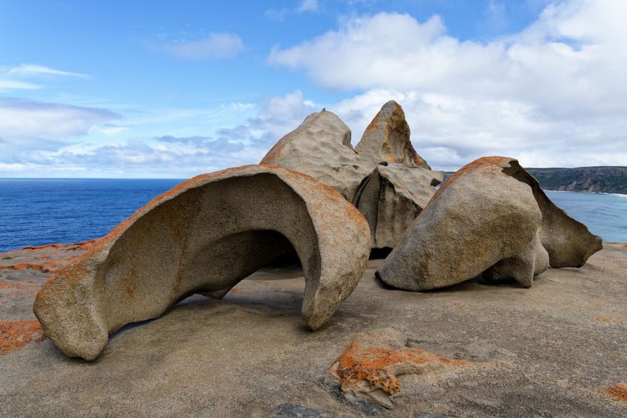
Wind-sculpted granite boulders on a headland above the ocean in Flinders Chase National Park. The orange is lichen.
Worth knowing: The Black Summer fires of 2019–2020 burned most of Flinders Chase. The bush is regrowing, and you can see how Australian forest recovers after fire.
Tip: Pay park entry online at parks.sa.gov.au before you go; the site closes in damaging winds.
Open on the map ↗↓ drive · 12 min · 9 km
9. Admirals Arch~40 min at the stop
A natural arch at Cape du Couedic, with New Zealand fur seals lounging on the rocks below.
Tip: The ferry at Penneshaw is about 2 hours away; leave a buffer before sailing time.
Open on the map ↗
Before you go
- Route times are estimates: walking, driving and a sensible pause at each stop. Add queues, traffic and swims yourself.
- Prices, timetables and trail status change. Check the venue's official site and the state transport app before you go.
- On beaches, swim only between the red and yellow flags. Use sun protection even when it is cloudy.