- Duration
- 3 days, ~570 km by car
- Who it suits
- Everyone
- Transport
- drive
- Start
- Lancelin sand dunes
- Finish
- Guilderton (Moore River mouth)
- Pace
- moderate pace
- Best time
- August–October: wildflower season in Lesueur National Park
- Budget per adult
- National parks: A$17 per vehicle per day (concession A$10); Lobster Shack factory tour: A$15, child A$7.50Prices as of: July 2026; transport and zoo prices October 2026
Getting there
Go by car. The Turquoise Coast starts well outside the city.
Stops in order
The text version of the route: stops, time at each and the legs between them. Times are estimates, without queues, traffic or swims.
Day 1: dunes and the Pinnacles
Day in Google Maps ↗1. Lancelin sand dunes~1 h 15 min at the stop
Blinding-white dunes the height of an apartment block on the edge of a fishing town. WA's favourite sandboarding pit.
Tip: Town shops hire out boards; up on the crests keep clear of the quad bikes and buggies.
Open on the map ↗↓ drive · 52 min · 57 km
2. Hangover Bay~45 min at the stop
An empty white beach inside Nambung National Park with picnic shelters; dolphins and sea lions drop into the bay.
Tip: The A$17 vehicle fee covers the whole day. Keep the receipt for the Pinnacles gate.
Open on the map ↗↓ drive · 5 min · 3.5 km
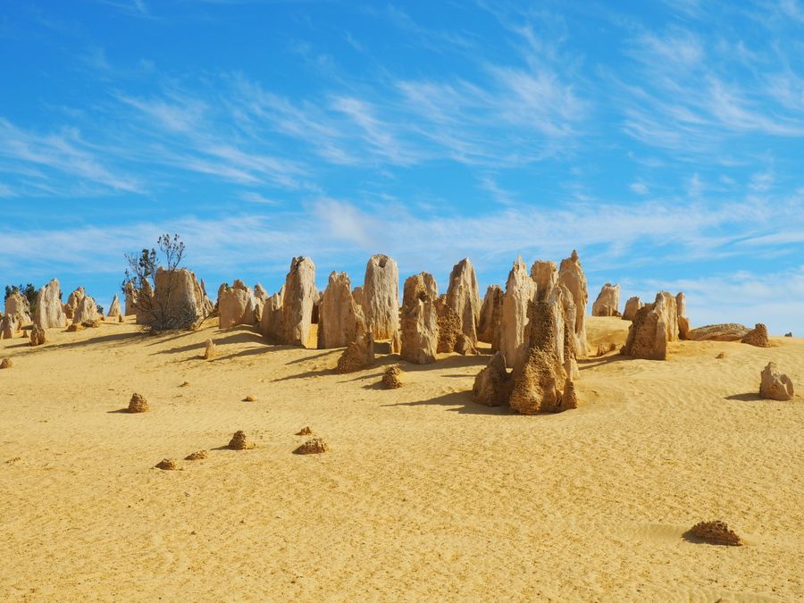
3. Pinnacles Desert (Nambung NP)~2 h at the stop
Thousands of limestone pillars rising from yellow sand: one of Australia's most surreal landscapes; entry A$17 per vehicle.
Tip: Stay for sunset: the low sun stretches shadows between the pillars and the day-tour buses are gone.
Open on the map ↗↓ drive · 16 min · 18 km
4. Overnight Cervantes
A cray-fishing town named after the ship Cervantes wrecked offshore: the Turquoise Coast's natural overnight base.
Tip: Order western rock lobster for dinner: it's caught right here.
Open on the map ↗
Day 2: stromatolites and Jurien Bay
Day in Google Maps ↗5. Lake Thetis stromatolites~30 min at the stop
A saline lake with living stromatolites (descendants of Earth's oldest life forms) ringed by a boardwalk loop trail.
Tip: Stay on the boardwalk: the fragile domes take millennia to grow.
Open on the map ↗↓ drive · 4 min · 2 km
6. Lobster Shack~1 h 30 min at the stop
A working rock-lobster factory with a beachside restaurant; the guided factory tour is A$15.
Tip: The kitchen runs 11:00–15:00, the shop 9:00–17:00. Factory tours run daily at 12:00 and 14:00, about 30 minutes; buy tickets on arrival in the gift shop.
Open on the map ↗↓ drive · 24 min · 27 km
7. Jurien Bay marina & sea lions~2 h at the stop
Capital of the marine park: boats leave the marina for island colonies of the rare Australian sea lion.
Tip: Swim tours leave in the morning and run about two hours. Book the day before.
Open on the map ↗↓ drive · 16 min · 18 km
8. Sandy Cape~1 h at the stop
White dunes and a turquoise lagoon on a protected cape: a quiet sunset spot fifteen minutes from town.
Tip: Sleep back in Jurien Bay: the accommodation choice is far wider.
Open on the map ↗
Day 3: Lesueur and the drive home
Day in Google Maps ↗9. Dynamite Bay (Green Head)~1 h at the stop
A perfect horseshoe of turquoise water framed by granite: one of the coast's most sheltered swimming bays.
Tip: The water is glassy in the morning: the best swim of the trip.
Open on the map ↗↓ drive · 28 min · 31 km
10. Lesueur National Park~1 h 30 min at the stop
One of the planet's richest floras: some 900 plant species along a sealed scenic loop with lookouts.
Tip: From August to October the slopes blaze with wildflowers; entry is the standard A$17 per vehicle.
Open on the map ↗↓ drive · 2 h 30 min · 165 km
11. Guilderton (Moore River mouth)~1 h at the stop
The Moore River dead-ends into ocean dunes: a calm freshwater lagoon for kids on one side, Indian Ocean surf on the other.
Tip: The route's final swim stop. Perth is just over an hour away.
Open on the map ↗
Before you go
- Route times are estimates: walking, driving and a sensible pause at each stop. Add queues, traffic and swims yourself.
- Prices, timetables and trail status change. Check the venue's official site and the state transport app before you go.
- On beaches, swim only between the red and yellow flags. Use sun protection even when it is cloudy.