- Duration
- 3 days, ~550 km by car
- Who it suits
- Everyone
- Transport
- drive
- Start
- Torquay & the surf museum
- Finish
- Port Campbell
- Pace
- moderate pace
- Best time
- October–April for long daylight; time sunset for the Twelve Apostles
- Budget per adult
- Almost everything is free: only the Cape Otway precinct charges entry (A$11)Prices as of: July 2026; transport and zoo prices October 2026
Getting there
This is a drive on the Great Ocean Road. From 16 October 2026 the Twelve Apostles lookouts need a booking, and that booking is free until April 2027.
Stops in order
The text version of the route: stops, time at each and the legs between them. Times are estimates, without queues, traffic or swims.
Day 1: Surf Coast
Day in Google Maps ↗1. Torquay & the surf museum~1 h at the stop
Birthplace of Rip Curl and Quiksilver and the official start of the Great Ocean Road.
Tip: A short stop before the highway. Leave the car in town and walk to the museum.
Open on the map ↗↓ drive · 12 min · 9 km
2. Bells Beach~30 min at the stop
A surf arena in an amphitheatre of cliffs. Every Easter it hosts the Rip Curl Pro, the world's oldest surfing contest and a World Tour stop.
Tip: Unpatrolled and not a swimming beach. Watch the surfers from the clifftop car park; echidnas turn up in the scrub.
Open on the map ↗↓ drive · 35 min · 36 km
3. Split Point Lighthouse~45 min at the stop
The white 1891 tower above Aireys Inlet: the 'White Queen' from the kids' series Round the Twist.
Tip: The photo is from the platform by the tower. The beach stairs are a separate steep walk. On a works day the tower may be shut and the platform stays open.
Open on the map ↗↓ drive · 25 min · 21 km
4. Lorne & Erskine Falls~1 h 30 min at the stop
A resort town in a eucalypt amphitheatre; ten minutes away a 30 m waterfall drops into a fern gully.
Tip: After the January 2026 floods only the upper lookout is open. The steps to the base and the river track are closed. Check Parks Victoria before you go.
Open on the map ↗
Day 2: the Otways
Day in Google Maps ↗5. Kennett River wild koalas~30 min at the stop
The most reliable wild-koala spot on the whole road: right in the canopy above Grey River Road.
Tip: Walk Grey River Road slowly and check the forks of the gum trees.
Open on the map ↗↓ drive · 30 min · 32 km
6. Apollo Bay~1 h at the stop
A fishing town on a broad bay: the best overnight base, with fish and chips by the harbour.
Tip: Sleep here. In summer book a room on the foreshore ahead. Fish is by the pier.
Open on the map ↗↓ drive · 15 min · 17 km
7. Maits Rest boardwalk~45 min at the stop
A boardwalk loop through cool-temperate rainforest: 300-year-old myrtle beeches and tree ferns.
Tip: The loop is short. Stay on the boardwalk. After rain the forest has leeches.
Open on the map ↗↓ drive · 25 min · 22 km
8. Cape Otway Lightstation~1 h at the stop
Mainland Australia's oldest surviving lightstation (1848). The tower is closed until about January 2027. The precinct is open Friday, Saturday, Sunday, Monday and Tuesday.
Tip: The current ticket is A$11 for an adult, A$10 concession, A$5 for a child aged 5 to 16, free under 5, and A$28 for a family of 2 adults and up to 3 children. Buy it on arrival. Open 9:30 to 16:30, last entry 16:00. Closed Wednesday, Thursday and Christmas Day.
Open on the map ↗
Day 3: Shipwreck Coast
Day in Google Maps ↗9. Gibson Steps~30 min at the stop
Cliff-cut steps drop to a wild beach where the 70 m cliffs and limestone giants tower from sea level.
Tip: Stay well back from the water: the swell here is unpredictable.
Open on the map ↗↓ drive · 2 min · 1.2 km
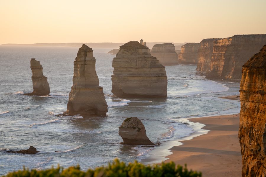
10. Twelve Apostles (book from 16 October 2026)~45 min at the stop
Victoria's defining view: limestone stacks up to 45 m rising from the surf.
Tip: From 16 October 2026 the Keerray Woorroong centre, the lookouts and the car park need a booking. The booking is free until April 2027, and a card is still needed to complete it. The centre is open 8:00 to 20:00. The light is best in the hour before sunset.
Open on the map ↗↓ drive · 7 min · 6 km
11. Loch Ard Gorge~45 min at the stop
A cove named for the clipper wrecked here in 1878: only two aboard survived.
Tip: The beach access steps are closed for geological instability until remediation is done. View the gorge from the clifftop lookouts and stay behind the fences.
Open on the map ↗↓ drive · 9 min · 10 km
12. Port Campbell~1 h at the stop
A tiny town on the only sheltered cove of the Shipwreck Coast: a final coffee before the drive back.
Tip: The town is small. Book a January night. Eat by the harbour while it is still light.
Open on the map ↗
Before you go
- Route times are estimates: walking, driving and a sensible pause at each stop. Add queues, traffic and swims yourself.
- Prices, timetables and trail status change. Check the venue's official site and the state transport app before you go.
- On beaches, swim only between the red and yellow flags. Use sun protection even when it is cloudy.